This is a new school which opened on 1st September 2015. We are waiting on performance data to create a full School Guide page.
Outstanding
NATIONAL AVG.
2.09


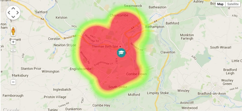

This pupil heat map shows where pupils currently attending the school live.
The concentration of pupils shows likelihood of admission based on distance criteria
This School Guide heat map has been plotted using official pupil data taken from the last School Census collected by the Department for Education. It is a visualisation of where pupils lived at the time of the annual School Census.
Our heat maps use groups of postcodes, not individual postcodes, and have naturally soft edges. All pupils are included in the mapping (i.e. children with siblings already at the school, high priority pupils and selective and/or religious admissions) but we may have removed statistical ‘outliers’ with more remote postcodes that do not reflect majority admissions.
For some schools, the heat map may be a useful indicator of the catchment area but our heat maps are not the same as catchment area maps. Catchment area maps, published by the school or local authority, are based on geographical admissions criteria and show actual cut-off distances and pre-defined catchment areas for a single admission year.
This information is provided as a guide only. The criteria in which schools use to allocate places in the event that they are oversubscribed can and do vary between schools and over time. These criteria can include distance from the school and sometimes specific catchment areas but can also include, amongst others, priority for siblings, children of a particular faith or specific feeder schools. Living in an area where children have previously attended a school does not guarantee admission to the school in future years. Always check with the school’s own admission authority for the current admission arrangements.
3 steps to help parents gather catchment information for a school:
Progress scores in reading, writing and maths could not be calculated in 2024 due to lack of baseline data during Covid 19. We show historic scores from the 2023 academic year as a guide
School Description
This is a new school which opened on 1st September 2015. We are waiting on performance data to create a full School Guide page.
 %
Parents Recommend This School
%
Parents Recommend This School
Responses taken from Ofsted Parent View
24/7 Customer Service: [email protected]


